Team Ghana Coastal Erosion
#HowToLDN Series
#HowtoLDN Series features the efforts of intersectoral country teams to implement their roadmaps to Land Degradation Neutrality #LDN. These country teams are supported by #GEO-LDN Flagship since our Global Dialogue Forum 2023 in South Africa. Today we feature the country #TeamGhanaCoastalErosion:
Meet the intersectoral country team in #Ghana, dedicated to protecting Ghana's 550km coastline, particularly the Keta Lagoon, from #CoastalErosion and flooding with a focus on sustainable marine management, safeguarding the natural ecosystems and achieving Land Degradation Neutrality (#LDN).
Discover how Ghana uses geospatial data for the entire process:
#TeamGhanaCoastalErosion uses earth observation tools to monitor shoreline recession and the rate at which shoreline is losing to the sea and the communities that are affected by coastal erosion. Through the collaboration with Geo LDN, the shoreline monitoring system has been established so that it can help address the issues to rehabilitate and restore the land that has been degraded to improve its productivity and ecological functions.
This use case is an example of how important #monitoring to develop early warning systems and use and #stakeholdermapping to implement sustainable and inclusive adaptation and mitigation measures.
💡Background
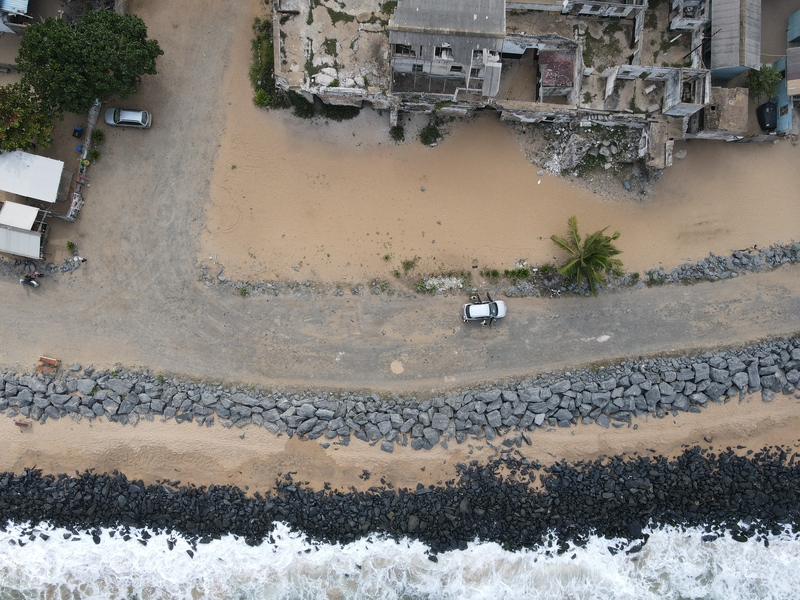
Ghana’s coastline is estimated to be 550km from which 367km, which accumulate to 2/3 of its entirety, are affected by #coastalerosion and flooding. The erosion and tidal waves threaten the livelihood of Ghana’s coastal residents, many of whom had to relocate due to their properties being destroyed in floodings. Utilizing geospatial data for monitoring coastal erosion is a key strategy to halt land degradation and ensure sustainable use of land resources in Ghana.
🛰The #HowToLDN use case from #TeamGhana
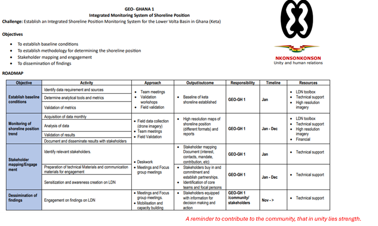
On their journey to achieving Land Degradation Neutrality (LDN), the Ghana country team has crafted a 2024 roadmap that align with the countries two planning systems: The National Development Planning System Act 1994 and Land Use and Spatial Planning Act 2017.
The goal was to develop, in collaboration with #GEOLDN, an integrated monitoring system for shoreline changes, mangrove health, and habitat expansion along Ghana’s coast while navigating challenges such as: measuring variables relevant to analyse coastal erosion; capacity to assess risk of coastal erosion by leveraging EO, drone technology, bathymetric surveys, and geospatial analysis in general.
The first step involved in establishing an Integrated Shoreline Position Monitoring System for the Lower Volta Basin in Keta, Ghana was establishing the baseline conditions through various team meetings, validation workshops and field validation. Field data collection was used to monitor the shoreline position trend and create high resolution maps of the different shoreline positions. Afterwards Team Ghana identified the relevant stakeholders and through different focus groups and meetings established stakeholder commitment and partnerships. The identification of relevant partnerships was an essential part to mobilize stakeholders for decision making and acting to preserve the Ghanaian coastline from its erosion.
Learn more about the LDN roadmap of Ghana: GhanaRoadmap
💪How the #GEO-LDN Flagship supported #TeamGhanaCoastalErosion
The primary role of the GEO-LDN flagship is to facilitate access to geospatial data that can support the risk analysis of coastal erosion as well as access to other databases (e.g. Digital Earth Africa) to support an inter-sectoral approach. The long-term objective is to continue the collaboration between the GEO-LDN flagship and Team Ghana and to integrate new information and technologies into already existing coastal management frameworks and policies.
Learn more about the GEO-LDN Flagship: GEO-LDN | About us
✅ Looking for support to drive LDN forward in your country? Contact us at: info@geo-ldn.org