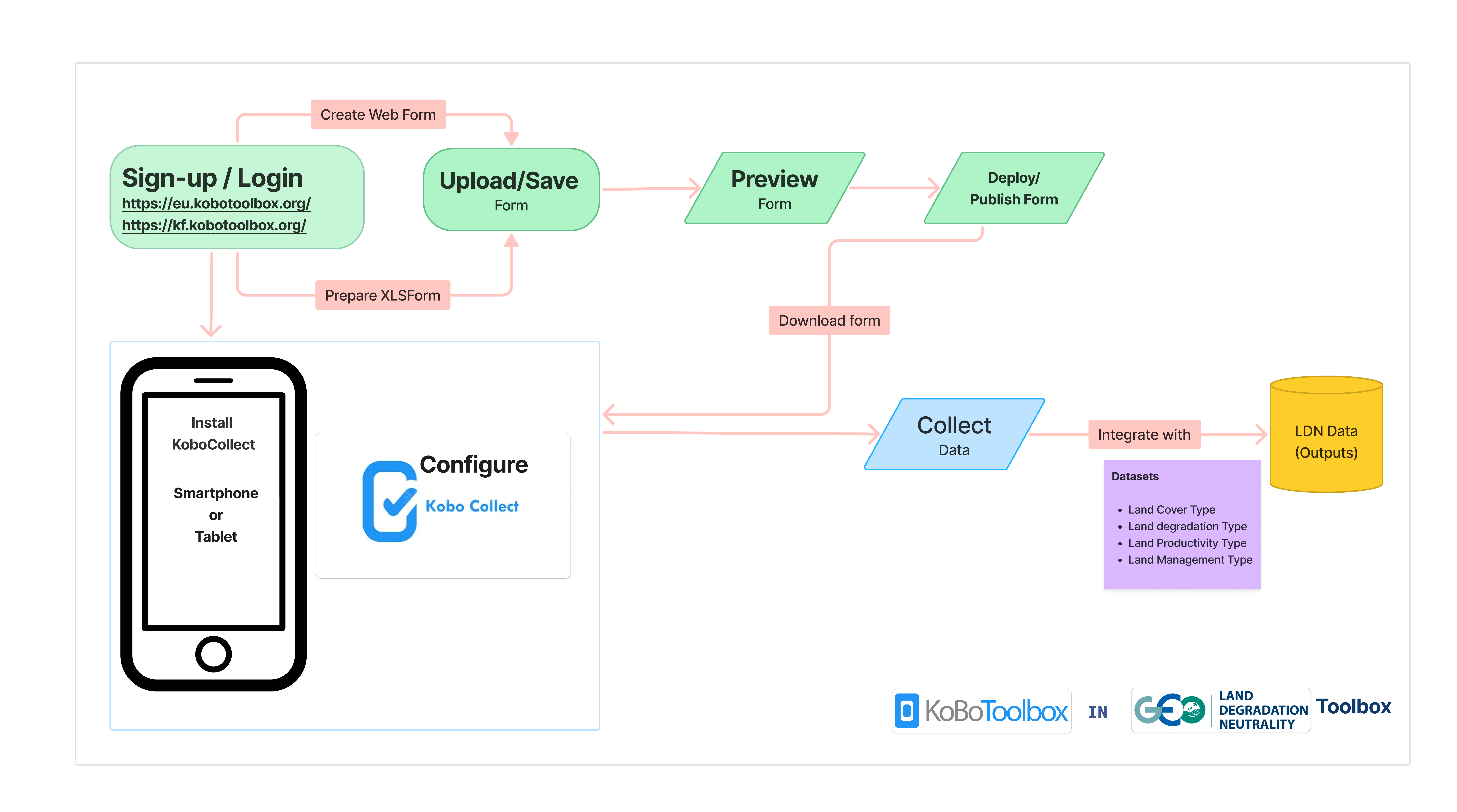
This tutorial is designed to guide users in integrating community-based knowledge into their reporting processes and enhancing their Decision Support System (DSS). It provides step-by-step instructions for using KoboToolbox and KoboCollect to set up and build forms, deploy, and collect field data for Land Degradation Neutrality (LDN) assessment. By the end of this tutorial, you will have a fully operational data collection system, customized to meet the specific requirements of LDN data collection.
Why need a digital data collection tool?
Efficiency and Speed: Allows to quickly collect, organize, and analyze data in real time, which is much faster than manual data collection. Reduce the time spent on data entry.
Accuracy and Minimization of Errors:
- Help to ensure that data is entered correctly. This reduces errors such as incomplete answers.
- GPS-enabled phones or tablets can capture location data accurately, which is critical for mapping activities.
Data Security and Backup: Provide secure, cloud-based storage, reducing the risk of losing data due to physical mishaps (like lost or damaged paper forms).
Customizable for Specific Needs: Can be tailored to the specific needs of your project; integrating multimedia elements (like photos or audio) that would be difficult to capture with traditional methods.
KoboToolBox and KoboCollect
- KoboToolbox is an innovative open source platform for collecting, managing, and visualizing data. It is the mostly widely used data tool for social impact initiatives across the globe.
- KoboToolbox makes it easy to develop forms for data collection. It also has features for managing projects, visualizing data, and building complex forms.
- KoboToolbox also allows you to translate questions into hundreds of different languages.
- Collect data offline or online on any device with web forms and the KoboCollect app.
- KoboCollect is an Android app to collect data on mobile devices. You can easily add forms from your KoboToolbox account to KoboCollect and transfer data collected to KoboToolbox.
- KoboToolbox makes it easy to analyze, visualize and download data.
What is an XLSForm?
- XLSForm is a form standard designed to make form creation easier by using Microsoft Excel.
- Forms are authored in a format that is easy to understand, using familiar tools like Excel or Google Sheets.
Excel Spreadsheet → Extensive Markup Language → Kobotoolbox
(Human Readable) (Machine readable) (Enketo)
Basic XLS form format
The Excel form has basically 2 main worksheets:
- survey: The survey sheet contains all the survey questions, type of questions, label, and other attributes that the Kobotoolbox can read. Example: What type of land degradation? What is the level of degradation?
- choices: The choices sheet contains ‘options’ that will be used for single or multiple-choice questions from the survey sheet. Example: Select the type of degradation: Soil erosion, Wind erosion e.t.c
NOTE: The sheet names are case sensitive
The survey sheet
The survey worksheet has 3 essential columns: type, name, and label.
- The type column specifies the type of data entry.
- The name column specifies the unique variable name for that entry.
Some rules for the name column:
- Each naming must be unique; No duplicates and are case-sensitive.
- Names can start with a letter or an underscore (a-z, _)
- Names can only contain letters, digits, hyphens, underscores, and periods.
- The label column contains the text to be displayed on the form. This text can also be translated to different languages.
The choices sheet
The choices worksheet contains 3 essential columns: list_name, name, and label.
- The list_name column allows the user to group together a set of related options.
- While both name and label columns are similar to the survey sheet.
| A | B | C |
| list_name | name | label |
| gender | male | Male |
| gender | female | Female |
| gender | nonbinary | Non-Binary |
| LD_type | O | No degradation |
| LD_type | W | Soil erosion by water |
| LD_type | E | Soil erosion by wind |
| LD_type | C | Chemical soil deterioration |
| LD_type | P | Physical soil deterioration |
| LD_type | B | Biological degradation |
Question types
Some more question types:
| Field type | Description |
| text | Prompts user for a text response |
| integer | Prompts user for a numeric response |
| audio | Prompts user to record or select audio from device |
| note | Displays text |
| calculate | Stores the result of an expression specified in the calculation column |
| select_one list_name | Prompts user to select one choice out of a list of options |
| select_multiple list_name | Prompts user to select multiple choices out of a list of options |
| begin_repeat | Indicates the start of a group of questions that are to be repeated |
| end_repeat | Indicates the end of a group of questions that are to be repeated |
| begin_group | Indicates the start of a group of questions |
| end_group | Indicates the end of a group of questions |
| geopoint | Prompts user to record a single point (geo location) |
| geoshape | Prompts user to record a polygon of points (first and last point are identical) |
| image | Prompts user to take or upload an image |
| video | Prompts user to record or upload a video |
| file | Prompts user to attach a file |
| date | Prompts user for a date response |
You can refer to the video tutorials for a more practical knowledge on setting up the entire workflow described here.
This tutorial was facilitated by Abubakar Isa Abubakar
